Course info
Course Description
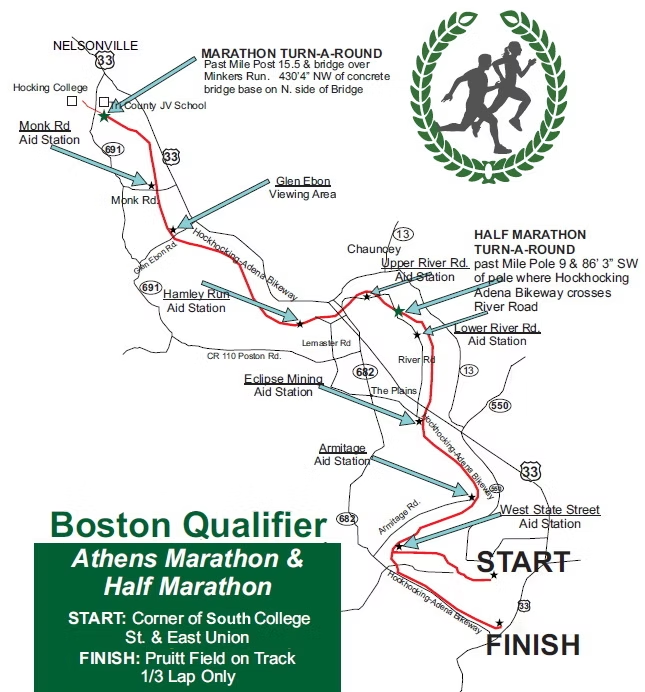
The races start together at the corner of South College Street and East Union Street in uptown Athens by Ohio University College Green. Both races will be on the scenic Hockhocking Adena Bikeway which is fast and flat. Both courses are USATF certified and well marked. The marathon course serves as a Boston Qualifier.
USATF Certified: Click to download certification!
OH22001DH – Athens Ohio Marathon
OH22002DH – Athens Ohio Half Marathon
Both races will begin by heading west on Union St. After approximately a half mile runners will turn right on Smith St., and than bear to the left onto Byard St. After approximately 300 meters runners turn right onto Shafer St, and than make a left onto W. State Street. The first mile mark is located on W. State Street just before entering W. State Street Park. About a mile and a half into the race runners will begin running northwest on the Hocking Adena Bikeway towards Nelsonville, Ohio. From W. State Street runners will make a right hand turn onto the path.
After turning right onto the bike path runners will pass bike way mile post 4.5 (BW MP 4.5) on the bike path. This is the two mile mark for both races. The half marathon turnaround will be .05 miles south of BW MP 9 approximately 6.45 miles into the race. The marathoners will continue heading north on the bikeway at this point, while the half-marathons will turn around and head back on the bikeway to the finish at Pruitt Field on Shafer St. The marathon turnaround will be at BW MP 15.5 approximately 13 miles into the race. Marathoners will then head back on the bikeway and finish at Pruitt Field. Both races will finish on the track at Pruitt Field.
Interactive Course Map
- Use the interactive map below to slide your cursor along the elevation profile and see where you are on the map!
- Toggle between the Marathon and Half Marathon with the drop down in the upper left-hand corner.
- Explore other map setting with the right-side toolbar, including the option to download the course GPX file.
Water & Aid Stations/Restrooms
Portable toilets will be available at Howard Park, the location of the Starting Line. Along the course, portable toilets will be placed at several of the aid station locations. There will also be ample portable toilets at the finish line at Pruitt Field.
Aid Station Fuel:
Water
Gatorade
Bananas and Oranges (*On second half of course only)
*we do not supply gels on the course.
Full Marathon Aid Station Distances
- West State St: 1.7 Miles
- Armitage Rd: 3.25 Miles
- Eclipse Mining Town: 4.9 Miles
- Lower River Rd: 6.9 Miles
- Upper River Rd: 7.75 Miles
- Hamley Run Rd: 9.25 Miles
- Glen Ebon: 11.2 Miles
- Monk Rd: 12 Miles
- Full Turnaround: 13.4 Miles
- Monk Rd: 14.7 Miles
- Glen Ebon: 15.5 Miles
- Hamley Run Rd. 17.5 Miles
- Upper River Rd: 19 Miles
- Lower River Rd: 19.8 Miles
- Eclipse Mining Town: 21.8 Miles
- Armitage Rd: 23.5 Miles
- West State St: 25 Miles
- Finish – 26.2 Miles
Half Marathon Aid Station Distances
- West State St: 1.7 Miles
- Armitage Rd: 3.25 Miles
- Eclipse Mining Town: 4.9 Miles
- Half Turnaround – 6.8 Miles
- Eclipse Mining Town: 8.7 Miles
- Armitage Rd: 10.35 Miles
- West State St: 11.8 Miles
- Finish – 13.1 Miles